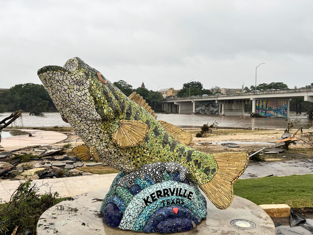
On Thursday afternoon, the Texas Hill Country prediction started to look dire.
At 1:18 p.m., the National Weather Service issued a flood watch, predicting that Kerr County and other areas of South Central Texas will get localized rainfall of up to 7 inches early Friday morning.
According to NWS radar estimates, up to 12 inches of rain had fallen in certain areas of the region while its occupants were asleep by the time the sun rose on July 4th, less than 24 hours later. In just two hours, the Guadalupe River gauge near the unincorporated village of Hunt, where the river splits, recorded a 22-foot rise, according to NWS Austin/San Antonio meteorologist Bob Fogarty. According to Fogarty, the gauge reached a depth of 29 feet before collapsing and submerging entirely.
[A refuge for generations of Texas girls, Camp Mystic turns into a tragic hotspot]
The deluge claimed the lives of at least 32 people. As of Saturday morning, the Kerr County sheriff’s office reported that dozens more people were still missing, including 27 young girls from a Christian summer camp. [More than fifty deaths were recorded by Sunday AM.]
Given the disaster’s scope and the frequency of significant flooding in this region of Texas, there are concerns about whether more could have been done to alert those who might be affected by the flood waters.
State and local officials quickly cited weather forecasts that failed to foresee the amount of rainfall. In the meantime, some forecasts recommended that, considering the obvious threats, local authorities and camp leadership should have been more active.
“It seems that evacuations and other preventative measures could have been taken to reduce the risk of fatalities had the organizers of impacted camps and local officials heeded the warnings of the government and private weather sources, including AccuWeather,” AccuWeather Chief Meteorologist Jonathan Porter wrote in a statement Saturday morning, making the tragic event that occurred in Central Texas a tragedy of the worst kind.
The Texas Division of Emergency Management’s chief, Nim Kidd, cited NWS estimates earlier in the week that predicted up to 6 inches of rain on Friday.
According to Kidd, it was unable to forecast the quantity of rain that fell.
Kidd was repeated by Kerr County Judge Rob Kelly. Kelly told reporters that the county had no reason to think that this would be anything like what has transpired here when they were asked why the campers along the Guadalupe were not evacuated.
Hours before the water levels peaked, however, flash flooding warnings were issued.
Around midnight, rain started to pour, and at 1:14 a.m. on Friday, the NWS issued the first flash flood warning, according to Fogarty. According to Fogarty, the Emergency Alert System, which transmits warnings to radios and televisions, as well as local emergency management and media should have responded to the alert in order to inform persons in danger.
Wireless Emergency Alerts, an emergency push notice delivered to all wireless phones in the disaster area via cellphone towers, are activated by all NWS flash flood warnings, including the one issued after midnight on Friday, according to Fogarty. According to Fogarty, the warning was updated nine times on Friday, resulting in distinct messages being sent via the Wireless Emergency messages and the Emergency Alert System.
The most severe warning occurred at 4:03 a.m. when the NWS declared a flash flood emergency, alerting people to a potentially fatal situation and recommending that they immediately evacuate to higher ground. Flash flood emergencies are declared based on a combination of reporting from the ground and rainfall data: According to someone, we must evacuate the area right once or else people would perish, Fogarty stated.
Following the firing of hundreds of meteorologists by the Trump administration this year as part of Elon Musk’s DOGE cuts, the floods coincided with worries about NWS personnel numbers. When the warning coordination meteorologist at the NWS Austin/San Antonio office revealed in April that he was leaving early because of funding cuts, there was conjecture that forecasters’ responsiveness might have been affected by vacancies.
According to Greg Waller, a service coordination hydrologist at the NWS West Gulf River Forecast Center in Fort Worth, the NWS forecasting offices were functioning normally at the time of the incident.
We had enough employees. Waller claimed that our technique was sufficient. This was us performing our duties as effectively as possible.
Former Weather Service officials told the New York Times this morning that staffing shortages were caused by the departure of seasoned individuals who would have assisted in coordinating with local authorities in the hours following the issuance of flash flood warnings overnight. Meanwhile, separate inquiries concerning the readiness of local communities, such as Kerr County’s apparent lack of a local flood warning system, have surfaced. Many of the killings took place in the county, which is about 50 miles northwest of San Antonio.]
According to staffing data from the NWS labor union, there are now four open positions out of 23 in the San Angelo forecasting office and six open positions out of 26 in San Antonio.
That was sufficient, according to Legislative Director Tom Fahy, to provide prompt warnings and forecasts both before and during the disaster.
We have seen no indication whatsoever that current budgetary or personnel constraints inside NOAA and the NWS were a contributing factor in this incident, according to a Texas-based independent meteorologist who echoed that assertion on his website.
One complicating element might have been the flood’s timing. The warnings were sent at the beginning of the Fourth of July weekend, when RV parks, cabins, and residences are crowded with visitors who may not be as knowledgeable about the dangers of flooding or the water’s habits.
According to a local flood gauge, the Guadalupe River near Kerrville increased in height from 1 to over 34 feet between 2 and 7 a.m. According to the gauge, the water peaked in Kerrville at approximately 6:45 a.m., hours after the warnings were initially issued.
The river height was less than two feet when the NWS declared a flash flood emergency, but it swiftly started to climb after the notice. Anything over 20 feet, which the gauge recorded just after 6 a.m. on Friday, is regarded as major flooding on the river.
Porter emphasized the risk of flooding at night, when many people are asleep and less likely to heed warnings.
The suddenness and severity of the storm caught city officials off guard, Kerrville City Manager Dalton Rice told reporters Friday.
“This occurred in a very short period of time and was not predictable,” Rice added. This isn’t a tornado where sirens are allowed. This isn’t a hurricane that requires weeks of preparation. It struck forcefully, and incidents like this occur in a highly isolated and important location. When those two factors come together, you get what happened today.
Rice responded that every camp is private when asked Saturday afternoon what protocols the county had in place to alert the summer camps along the river to flooding emergencies. He claimed that because of how quickly everything happened, there wasn’t much time for warnings in this instance.
He stated that search and rescue efforts are the main priority at the moment, and inquiries concerning warnings will be addressed at a later time.
Meanwhile, Waller pointed out that the region has a history of flooding.
According to Waller, this is the worst scenario we prepare all of our new forecasters for in my line of work.
Because of the local topography, precipitation projections that are only 20 miles wrong could have a significant impact on completely distinct river basins, he said.
Given the history of the river, Porter said it was quite alarming to hear about people being awakened by fast rising water and being forced to leave during the emergency rather than much earlier after the warnings were first provided.
The area has already seen devastating flooding, including the Wimberley flood in 2015, which claimed 13 lives, and significant floods in 2007 and 2002. Kerrville and neighboring settlements along the Guadalupe River were damaged by a flood in July 1987.
The Tribune of Texas, Paul Cobler. Alejandra Martinez and Jessica Shuran Yu provided reporting assistance.
![]()
The Texas Tribune first published this article here. The Texas Tribune is a nonpartisan news outlet that is supported by its members that informs and engages Texans on state politics and policy. Visit texastribune.org to learn more.
