Written by Hatim Sharif
Shallow rivers meander through rocky valleys and among hills in the Texas Hill Country, which is renowned for its scenery. Because of its location, it is also one of the most deadly areas for flash flooding in the United States.
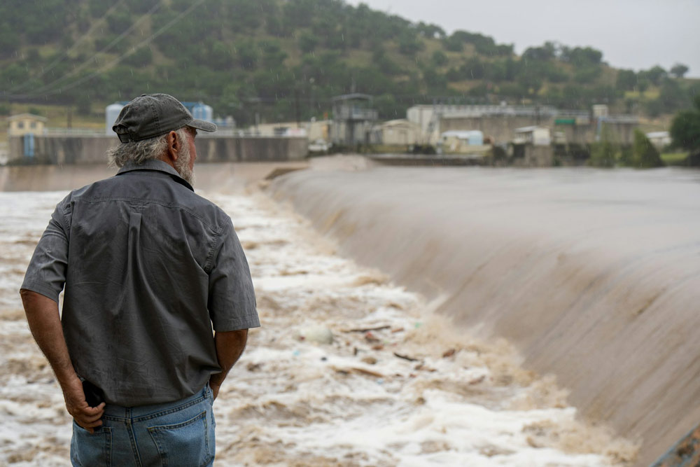
About 70 miles northwest of San Antonio, a region of the Hill Country that was home to small communities and summer camps was hit by a flash flood in the early hours of July 4, 2025. Officials said on July 7 that at least 75 individuals had killed in Kerr County and that 10 females from one group were still missing. In other counties, at least 19 fatalities were reported.
A torrential downpour caused water to sheet down the hillsides and into rivers, causing the flooding to start. The Guadalupe River received the creeks’ runoff.
The speed at which the river flooded was indicated by a water gauge near the camp in Hunt, Texas: According to data from the National Weather Service, the Guadalupe River was rising at a rate of almost one foot per five minutes at the gauge at around three in the morning on July 4. It had climbed almost 20 feet by 4:30 a.m. The river surged much more quickly as it passed Kerrville as it flowed downstream.
Flood specialistHatim Sharif, a civil engineer and hydrologist at the University of Texas at San Antonio, describes the dangers of this region of the nation, which is referred to as Flash Flood Alley.
What makes Hill Country so prone to flooding?
When it comes to flood deaths, Texas tops the US by a significant margin. After analyzing data from 1959 to 2019, my colleague and I discovered that 1,069 individuals had perished in flooding in Texas during that time. Louisiana had the next-highest number, 693.
Hill County has seen a large number of those flood-related fatalities. It is situated inside the region known as Flash Flood Alley, which is a crescent-shaped stretch of land that stretches westward from the vicinity of Dallas to San Antonio.
When it floods, the water flows swiftly and the slopes are steep. Since the soils in this semi-arid region don’t absorb much water, water sheets off quickly, allowing shallow creeks to rise swiftly.
These creeks can produce a flood of water when they meet a river, which can destroy houses, wash away automobiles, and, regrettably, kill anyone in its path.
Devastating flash floods have occurred in the Hill Country. A flash flood akin to the one in 2025 was caused by torrential rains in western Kerr County in 1987, which swiftly swamped the Guadalupe River. In the rushing waves, ten teenagers are being pulled from a camp.
On June 12, 2025, a flash flood at the eastern fringe of Hill Country struck San Antonio, killing 13 individuals whose cars were washed away by high water from a rapidly flowing creek near an interstate ramp in the early hours of the morning.
Why does the region get such strong downpours?
The Balcones Escarpment is one of the reasons why the Hill Country experiences intense downpours.
A geologic fracture produced the escarpment, which is a series of cliffs and steep slopes. Warm Gulf air condenses and can release a lot of precipitation when it rushes up the escarpment. That water fills the streams and rivers below as it swiftly cascades down the slopes in a variety of directions.
The warmer atmosphere can retain more moisture as temperatures rise, which raises the possibility of rainstorms and flooding.
In San Antonio, where there is a lot of paved terrain and outdated drainage to control runoff, the same impact may increase the risk of flash floods.
What can be done to improve flash flood safety?
First and foremost, people should be aware of the causes of flash floods as well as the rapidity of water rise and movement. Dry or shallow creeks can swiftly fill up with swift-moving water and prove lethal in many arid regions. People should therefore be mindful of the dangers and keep an eye on the weather.
With more accurate models of the physics and water velocity at various locations, flood predictions may also be improved.
For instance, a variety of rainfall scenarios can be provided using probabilistic forecasting, allowing authorities to plan for the worst. Implementing prompt evacuations or road closures could also be aided by a scientific framework that links rainfall projections to local impacts like streamflow, flood depth, and water velocity.
For drivers in particular, education is crucial. A car can be washed away by one to two feet of flowing water. Fast-moving water can flip a vehicle and transport it away, despite people’s belief that their SUVs and trucks can handle anything.
When there is a high chance of flooding, officials can also take extra action to blockade roads to keep people from driving into danger. We discovered that cars were implicated in 58% of Texas flood deaths over the previous 60 years. One example was the storm that hit San Antonio on June 12. Drivers had terrible vision because it was early in the morning. Rapidly rising floodwater from a nearby creek struck the vehicles.
![]()
At the University of Texas at San Antonio, Hatim Sharif teaches civil and environmental engineering.